Lofoten Ultra-Trail® // 50 miles Lofoten Relay (Lofotstafetten)
SATURDAY 30TH OF MAY 2026
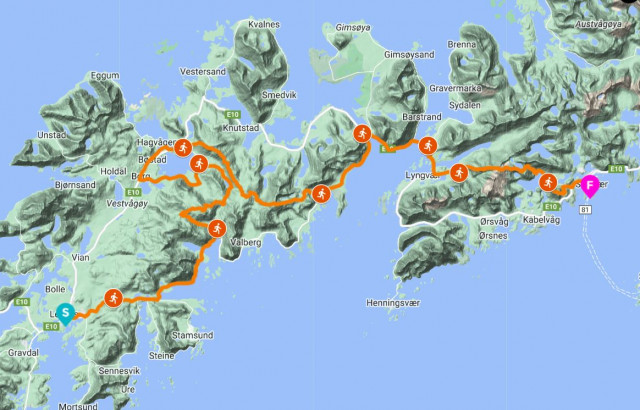
Starting at Scandic Hotel in Leknes, in the middle of Lofoten, this is a distance giving you a great experience crossing the mountains all the way to Svolvær.
50 miles RELAY (stafett) is a great teambuilding product, where you work together before and during the race. It is a great way to experience Lofoten, which is often described as the world’s most beautiful islands. The race consist of 10 stages, from 5 km to 15 km. Some stages are flat and some have more elevation and technical terrain.
The relay course is the same as the individual course. If you participate 10 years and switch legs every year you may finish the whole 50 miles course after 10 years. This is a pretty cool way to experience Lofoten.
Please note – race brief the day before the start (late afternoon).
Date/time: Saturday 30th of May at 09:00
Start: Leknes, Vestvågøy
End: Svolvær, Austvågøy
Track: Entire track is marked
Distance: 88 KM
Height meters: 3500+ M
Number of stages: 10
Length of stages: from 4 km to 15 km
Team participants: 2-10 athletes
Maximum number of teams: 50
CUT OFF // 50 MILES RELAY
61 KM/Kleppstad 11 hours after start
74 KM/Kongsmarka 15 hours after start
STAGE 1 // LEKNES - HAGSKARET 4KM
DISTANCE: 4km
GPX STAGE 1: download here
KEYNOTES: Road running and up hill
DESCRIPTION: The race will start at Scandic Leknes and follow the road towards Hagskaret. Mostly asphalt road on stage 1.
STAGE 2 // HAGSKARET - BRUSTRANDA 13KM
DISTANCE: 13km
GPX STAGE 2: download here
DESCRIPTION: From Hagskaret you follow the road until taking a left towards Valberg when you hit the fjord. Follow the Valberg Road until you reach Brustranda Fjordcamping. Asphalt running.
STAGE 3 // BRUSTRANDA - LAUVDALEN 13KM
DISTANCE: 13km
GPX STAGE 3: download here
KEYNOTES: Trailrunning in the mountains and some gravel road in the end.
DESCRIPTION: From Brustranda you follow the valley along Steinbakkelva until you take east towards Vårliheia and Tjønndalsheia. Further you run a trail downhill towards Lauvdalen where you hit the gravel road for the last 3 km.
STAGE 4 // LAUVDALEN - TORVDALSHALSEN 11KM
DISTANCE: 11km
GPX STAGE 4: download here
KEYNOTES: Road running
DESCRIPTION: Flat run on asphalt around Indrepollen.
STAGE 5 // TORVDALSHALSEN - VIKJORD 15KM
DISTANCE: 15km
GPX STAGE 5: download here
KEYNOTES: Mountain passing in the footprints of Vikings. Nice trails and great views!
DESCRIPTION: From Borgfjorden you will follow the farm road towards the mountain. There is a grass/gravel road up the first mountainside. Before the road ends you are to get onto a trail towards Vardheia where you enter a trail towards the ridge of the Dalstuva mountain. It’s a magically flat mountain top surrounded by peaks. Follow the ridge down towards the small lakes and then a trail leading to Vikjorden and a service point down at the main road.
STAGE 6 // VIKJORD - SMORTEN 6KM
DISTANCE: 6km
GPX STAGE 6: download here
KEYNOTES: Road running
DESCRIPTION: Nice sea side road running on asphalt with to Smorten.
STAGE 7 // SMORTEN - KLEPPSTAD 6KM
DISTANCE: 6km
GPX STAGE 7: download here
KEYNOTES: Road running with a view!
DESCRIPTION: More sea side running on asphalt finishing with a large bridge before Kleppstad.
STAGE 8 // KLEPPSTAD - OLDERFJORDEN 5KM
DISTANCE: 5km
GPX STAGE 8: download here
KEYNOTES: Old farmroad, some asphalt and gravel road.
DESCRIPTION: First part is on an old farm road, before you reach the main road for a couple of km. Last part is on gravel road before the mountains awaits on the next stage.
STAGE 9 // OLDERFJORDEN - KONGSMARKA 9KM
DISTANCE: 9km
GPX STAGE 9: download here
KEYNOTES: mountains, partly steep and technical running
DESCRIPTION: First you cross a stream before you start climbing towards mountain Jordtind, Nonstind and Spisstind. Some techical and steep sections. After the first mountain you descend towards a lake before a small climb next to mountain Dronninga. From there you follow the trail down to lake Store Kongsvatn and transition zone in Kongsmarka.
STAGE 10 // KONGSMARKA - SVOLVÆR 6KM
DISTANCE: 6km
GPX STAGE 10: download here
KEYNOTES: Crossing the final mountain and some road running before finishing.
DESCRIPTION: A tough climb awaits! The route passes over the mountain Tjeldbergtind (367mas) and take you down to a gravel road on the other side. Follow the road down to the main road and start on the final kilometers towards the town square of Svolvær.
When you run through the tunnel continue straight till you hit the harbor, make a right turn and follow the quay towards the finish line. And you’re done.. Congratulations!
Please read the Race Manual below for further details about the race!
Race details
Distances
Map
Route illustrated in the map below in orange color. Use zoom function in if you want to get a more detailed view of the course. Point your mouse over the map markers for more information.

Click image for bigger map