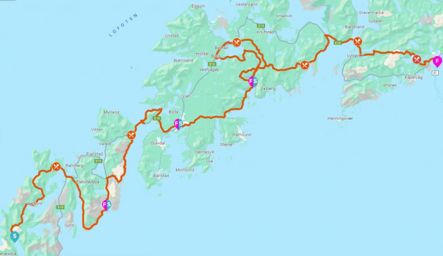
Lofoten Stage Run // 170 km Expedition Run
An epic all inclusive expedition run through the world's most beautiful achipilago. 6 days. 4 stages. Memories for a life time.
Click to open stage info:
STAGE 1 // WEDNESDAY: KJERKFJORDEN – NUSFJORD 39KM
DISTANCE: 39km
ELEVATION: 1600m
GPX STAGE 1: download here
KEYNOTES: 4 mountain passes, some road running, scenic bridges and historic coastal trails.
DESCRIPTION:
The starting line is in Kirkefjorden in the bottom of Reinefjorden. To get there all participants will be transported by boat from Reine. The boat ride takes about 20 minutes and it is a scenic experience! The first 20 km are terrain and maybe the most demanding part of the entire route with several mountains to pass. The trail is technically demanding and there is only a few km on gravel road from Selfjord till you take off towards Kvalvika. The trails will take you past two beaches in Kvalvika and you will run on the actual beach before the next mountain passing towards Fredvang. Service station located at Fredvang.
From Fredvang you’ll get the first leg on asphalt on your way towards Ytre Skjelfjord. After about 6 km the road becomes a gravel road the last 6 km to Nesland. Here you enter a historic fishermen’s trail towards the iconic village of Nusfjord. The trail is about 5 km and has a technical trail that also require some light “climbing” over rocks and a short ladder.
ACCOMODATION: Stay in a wonderful rorbu Nusfjord Arctic Resort, one of the most scenic fishermans villages in Norway.
STAGE 2 // THURSDAY: NUSFJORD – LEKNES 34KM
DISTANCE: 34km
ELEVATION: 1200m
GPX STAGE 2: download here
KEYNOTES: 1 mountain pass. Techical and scenic coastal trails to Napp. Underwater tunnel and terrain leg around the mountain Offersøykammen before the last kilometers on asphalt towards Leknes.
DESCRIPTION:
From Nusfjord you’ll follow the main road for about 3 km before you enter the trail to Napp. The trail from follows the coastline and has a lot of ups and downs. Very demanding so keep the focus. You will have a great view towards the next island on the race – Vestvågøy.
The route from Napp continues through an underwater tunnel (1780 m) before you make a sharp turn to the right after the exit to get on the trail around Offersøy.
The trail around Offersøy is very nice and easy to begin with. When you pass the cave from the stone age after about 2 km on the trail, the condition of the trail changes to more technically. There hardly is a trail. In this middle section follow the rocky coastline. The last kilometers of the trail around Offersøy is flat.
The last kilometers towards Leknes is flat road running on asphalt.
ACCOMODATION: Stay at Lofoten Rorbuutleie.
STAGE 3 // FRIDAY: LEKNES - ROLVSFJORDEN 52KM
DISTANCE: 52km
ELEVATION: 1900m
GPX STAGE 3: download here
KEYNOTES: Starting with some km road running, scenic mountain trail running, a bit more road running before super nice trails again. A couple of km gravel road in the end.
DESCRIPTION:
In the morning you will start with some scenic road running from Leknes to Rolvsfjorden to warm up your body. From Rolvsfjorden you hit the trails accross the first mountain and into the valley on the other side. Thereon it’s a flat run towards the service- and checkpoint at Borgfjorden.
From Borgfjorden you will follow new trails accross the mountain. After some great trail running you will cross a nice ridge before you get on a gravel road for the last couple of km before you reach Rolvsfjorden.
ACCOMODATION: Stay in cosy cabins at the scenic fjord camp Brustranda Fjordcamping.
STAGE 4 // SATURDAY: ROLFSFJORDEN – SVOLVÆR 45KM
DISTANCE: 45km
ELEVATION: 2350m
GPX STAGE 4: download here
KEYNOTES: The final mountain passes are ahead of you, enjoy them! Some road running as well between the mountains.
DESCRIPTION:
Before the road ends you are to get onto a trail towards Vardheia where you enter a trail towards the ridge of the Daltuva mountain. It’s a magically flat mountain top surrounded by peaks. Follow the ridge down towards the small lakes and then a trail leading to Vikjorden and a service point down at the main road.
Then you’ll get about 10 km of asphalt until you get to the service- and checkpoint after you have passed over the Gimsøystraumen bridge. After a little trail section the route follows the main road for about 1,5 km before you hit gravel road towards Olderfjorden S. You will now enter a hard and tecnical mountain section above Jordtind, Nonstind and Spisstind. After the ridge you’ll descend to lake Vestre Nøkkvatnet, before you pass behind the ridge of the mountain Dronningtinden, and the decent towards a power station.
You will continue along a gravel road until you turn at the end of the lake towards the final mountain – Tjeldbergtinden. The route passes over the mountain and take you down to a gravel road on the other side. Follow the road down to the main road and start on the final kilometers towards the town square of Svolvær.
When you run through the tunnel continue straight till you hit the harbor, make a right turn and follow the quay towards the finish line. And you’re done.. Congratulations!
ACCOMODATION: Stay next to the finish line in the comfortable Thon Hotel Lofoten with their award winning breakfast which will be a great treat for a sore body the next day.
